Making Way for the Wild
First published on
March 31, 2026
By Shatakshi Gawade and Yash Sadhak Shrivastava
A step off National Highway 44 stands a tidy building, its camouflage paint and the deciduous forest around it, belying its hi-tech nature. Housed on the first floor of this Maharashtra Forest Department outpost in the Pavani range of the Pench Tiger Reserve is the monitoring room for underpass number eight. CCTV cameras installed there quietly record wildlife as they make their way safely between the two parts of the forest on either side of one of India’s busiest four-lane highways.
The animal underpasses on National Highway 44 in Maharashtra and Madhya Pradesh, completed in 2018 and 2021, respectively, are pioneering mitigation measures that made way for several similar structures across the country. NH44 runs through the Pench Tiger Reserve and the Kanha-Pench corridor in Maharashtra as well as Madhya Pradesh. As of 2023, there were 67 locations where mitigation structures have been built on national highways across the country. But here’s the catch – researchers have identified at least 192 wildlife corridors in just the Central Indian and Eastern Ghats landscape.
A Wildlife Conservation Trust study notes that “not a single tiger sub-population in the Central Indian Landscape is genetically viable in the long run by itself”. The long-term survival of tigers, a keystone species, depends on the connectivity of sub-populations via a network of intervening forest corridors. And for this, animal underpasses are a key component.
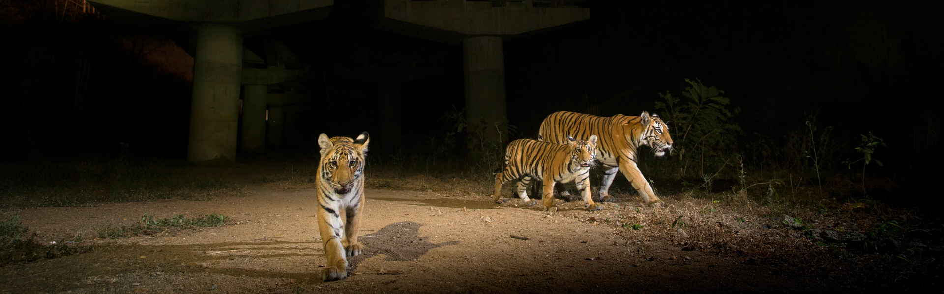
Nand Kishor Uikey, a forest guard in Pench in Madhya Pradesh, pointed to the pugmarks of a tigress crossing the largest underpass in the state. “We see signs of tigers using the infrastructure every 10 days. Around 15 days ago, I saw a gaur using the structure. These underpasses are very important, as wild animals can now move freely and don’t need to go onto the road, which could result in accidents,” Uikey said.
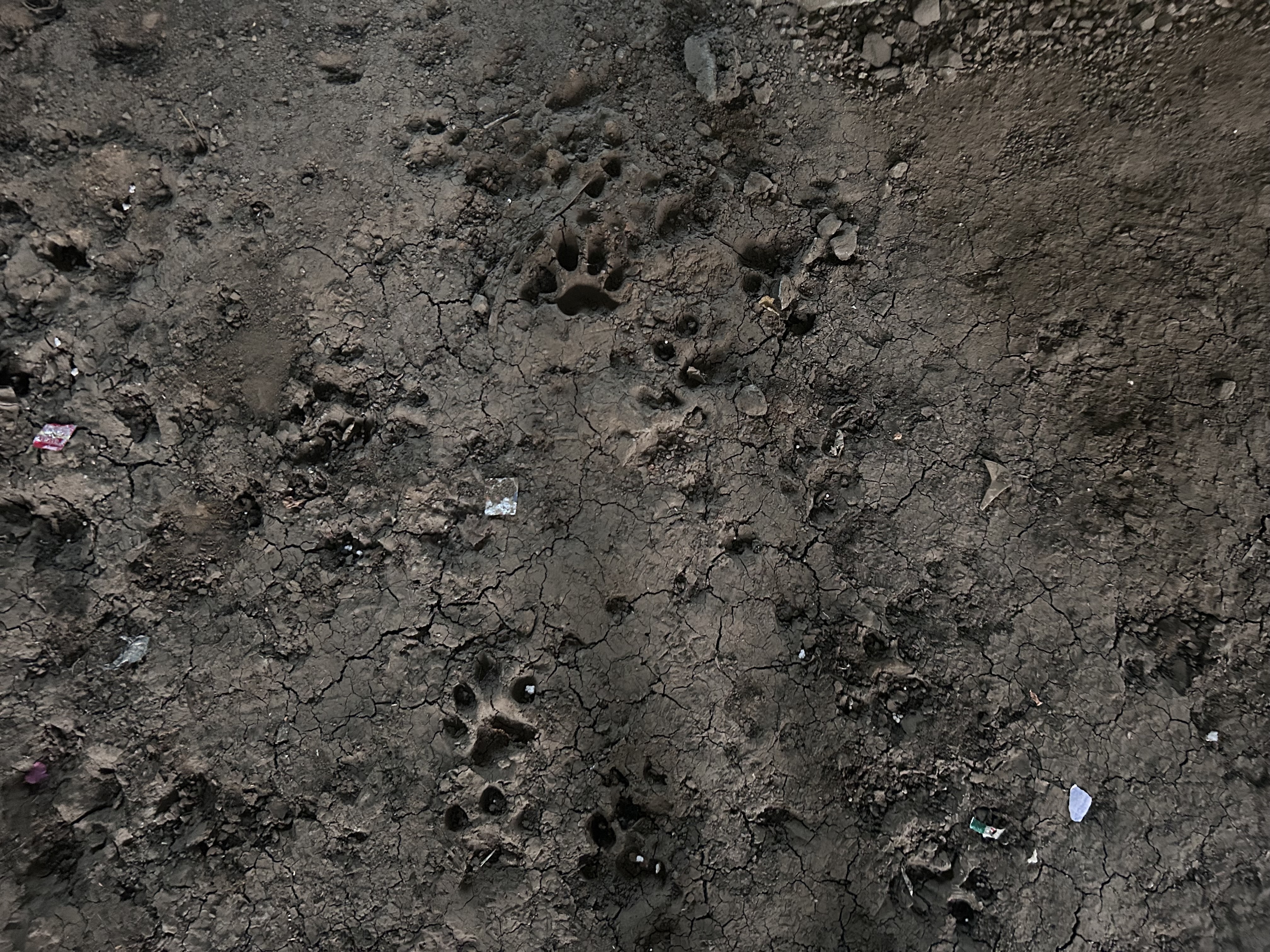
Pugmarks of a tigress recorded under the 1,400-m. underpass on NH44 in Madhya Pradesh. Photo: Yash Sadhak Shrivastava
(Some) Right of Way
An underpass, which looks like any ordinary bridge to speeding vehicles, is one of the ways to provide animals a route to cross from one part of the forest bifurcated by the road, into another. It is also a means to prevent roadkill. The focus is largely on maintaining connectivity; the absence of roadkill could mean wild animals are not able to cross at all, rather than confirming that they are using the underpasses.
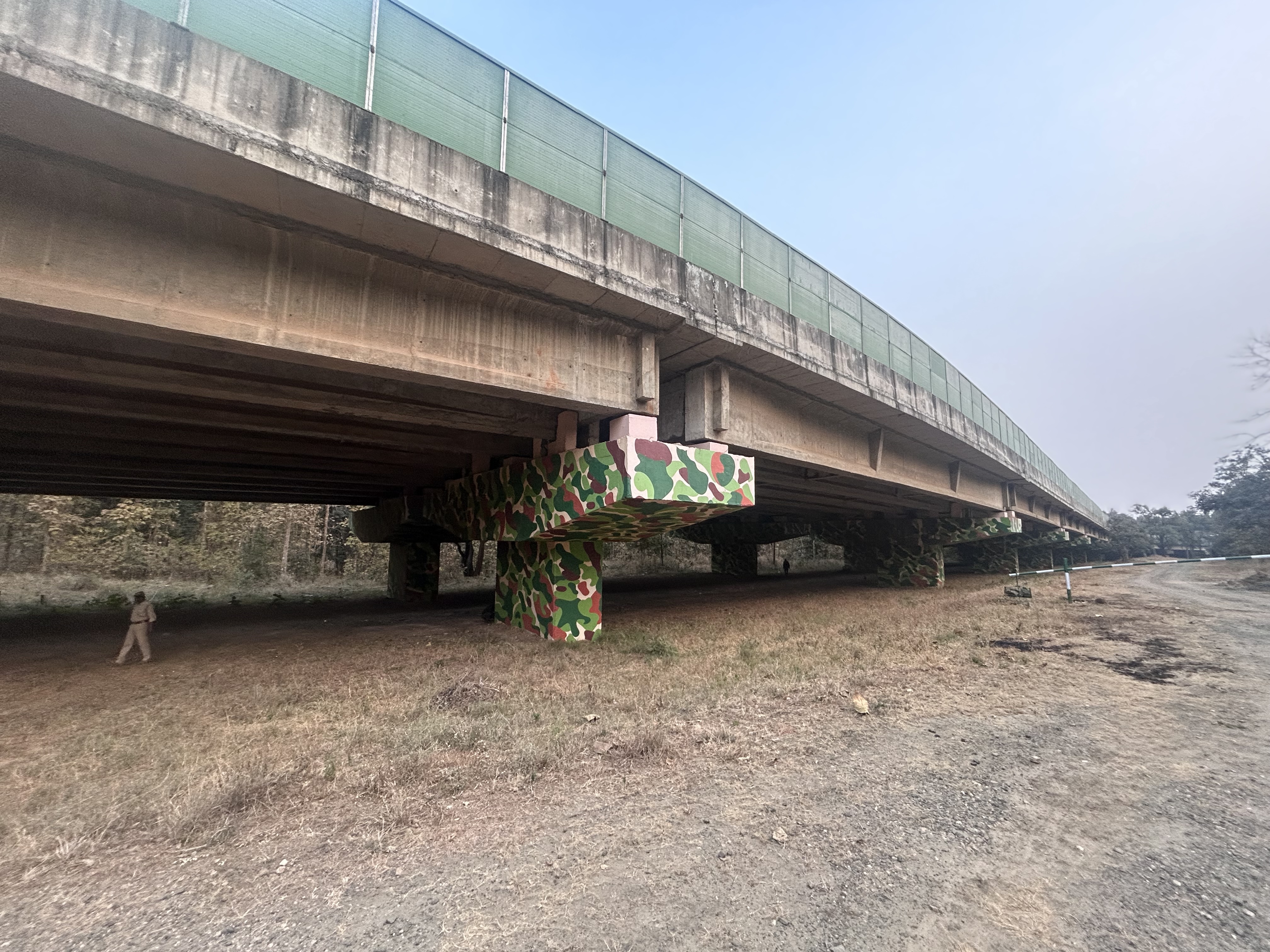
The Mansar (Maharashtra) to Madhya Pradesh border section of NH 44 has three animal underpasses, six other structures, 15 minor bridges and 66 culverts. The longest underpass in Maharashtra is 750 m. The section from the Maharashtra border to Seoni in MP has a 1,400 m. elevated corridor, the longest underpass on NH44, two of 500 m., one each of 300 m. and 120 m., and 10 that are between 100 and 30 m. There are noise and light barriers on all structures only on the MP side. “Apart from reducing light and sound disturbance, these barriers also funnel animals towards safe crossing points,” Aditya Joshi, Head of Conservation Research at the Wildlife Conservation Trust said. “In effect, they guide wildlife to the underpasses instead of allowing them to wander onto the highway.”
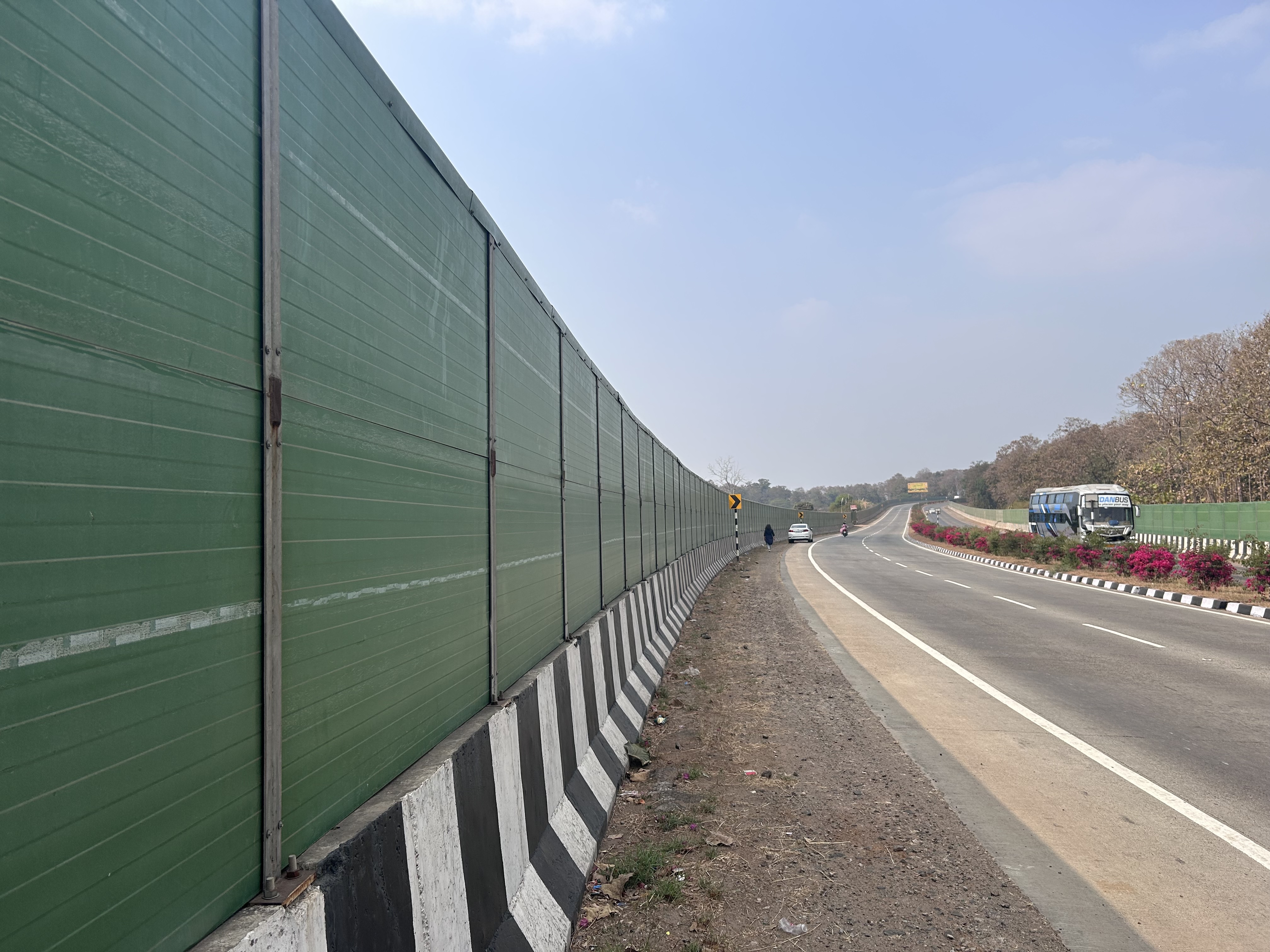
Noise and light barriers have been installed along a 29-km. stretch of NH44 between Mohgaon and the Khawasa border in Madhya Pradesh. They are designed to reduce disturbance and guide wildlife toward safe crossing points. Photo: Yash Sadhak Shrivastava
“We regularly see tigers, leopards, chital and monkeys using the underpass. CCTV cameras were installed here in 2022, and we maintain daily records in wildlife registers, one for tigers and another for other animals,” said Umesh Sudhakar Bavle, a forest guard in the Pavani range of the Pench Tiger Reserve, Maharashtra.

Manual records of wildlife using an underpass, excluding tigers, maintained in a register at the Pavani range in the Pench Tiger Reserve, Maharashtra. Photo: Yash Sadhak Shrivastava
Manual records of tigers using an underpass, maintained in a register at the Pavani range in the Pench Tiger Reserve. Photo: Yash Sadhak Shrivastava
NH44 is the longest highway in India, running from Srinagar to Kanyakumari. Beautiful forests flank either side of the highway as it passes through the Kanha-Pench corridor and the Pench Tiger Reserve, which is home to tiger, gaur, Indian pangolin and several other animals.
The year was 2006. A proposal emerged to upgrade NH44 – then known as NH7 – from two lanes to four lanes; this highway is an arterial passage for goods moving between Kanyakumari and Srinagar. Over the next 10 years, a slew of NGOs, researchers, lawyers, bureaucrats and government departments, different courts and court committees got involved in a tussle – one side fighting to ensure wildlife passages were protected, the other trying to avoid the structures altogether. This suggests a troubling trend where mitigation is achieved primarily through litigation, rather than proactive planning, observed researchers Milind Pariwakam (a road ecologist) and Sheetal Kolhe (a spatial analyst with the Landscape Research and Conservation Foundation) in their study ‘Recommendations for adding corridors to TCPs of 30 Tiger Reserves in the CI&EG Landscape’. Pariwakam was instrumental in the campaign to get mitigation measures for tigers and other wildlife on NH44, as a researcher and through personally-funded legal efforts.
“Linear infrastructure, by nature, splits landscapes, while wildlife such as tigers and leopards depend on natural movement across territories,” said Punit Goyal, the Deputy Director of Pench Tiger Reserve in Madhya Pradesh. “This movement allows gene flow, prevents inbreeding and helps wildlife populations remain robust against disease and climate change. If such movement is disrupted, animals may enter villages, leading to human-wildlife conflict, or attempt to cross highways and railways, risking casualties for both animals and humans. Mitigation structures such as underpasses, overpasses and sound barriers are therefore essential to ensure that wildlife movement between landscapes is disturbed as little as possible.” Eleven tigers have died in Madhya Pradesh in the first one and a half months alone of the year 2026, and 55 in 2025. Just last week, a radio-collared tiger was allegedly poisoned to death near Satpura Tiger Reserve in MP, following which five people were arrested. The accused allegedly took this step as the big cat had killed their cattle. Meanwhile, 41 tigers died in Maharashtra in 2025, of which eight lost their lives in accidents.
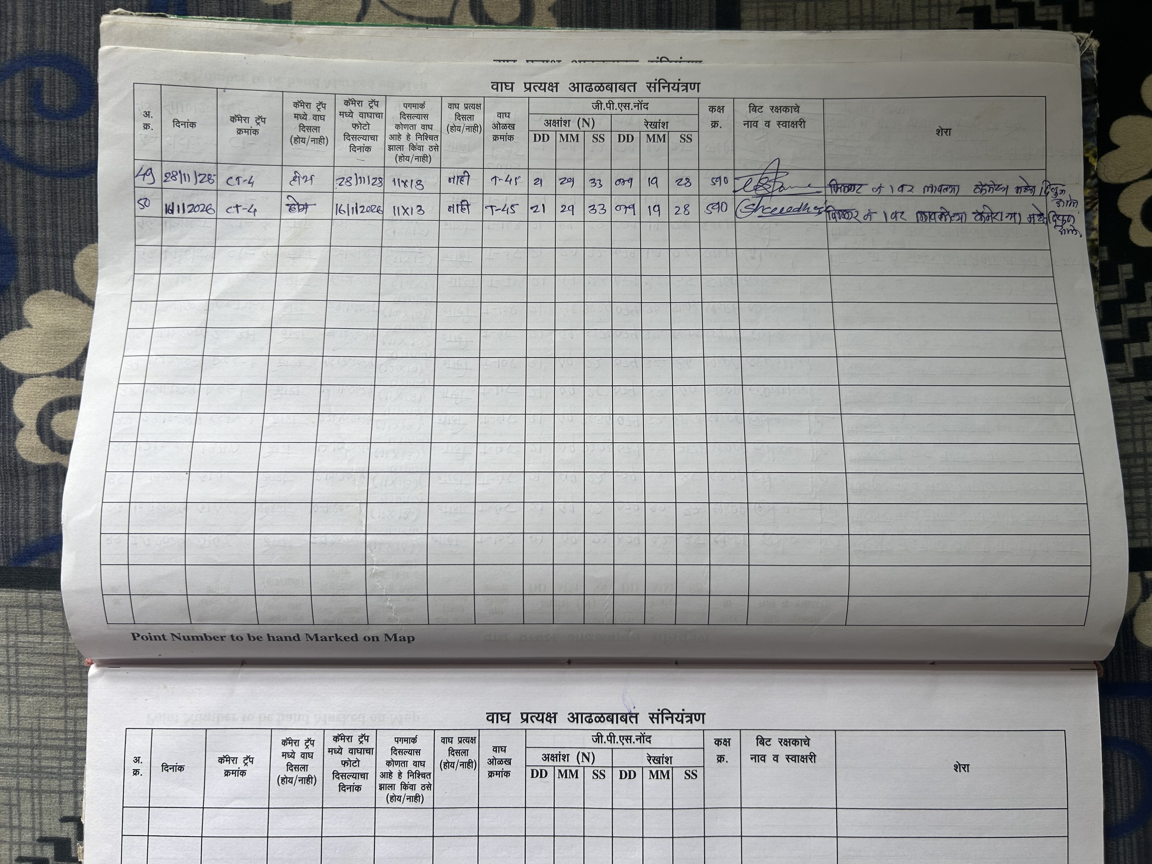
Now, Maharashtra Forest Department field staff regularly record wildlife and human movement through the underpasses. “Monitoring happens around the clock, and we also keep an eye on any humans passing through. One staff member is on duty during the day and another at night to keep track of the system,” Sudhakar added. The footage is stored for three months before being transferred to a hard drive, and it is then sent to the head office. These CCTV cameras operate separately from the camera traps installed by the Wildlife Institute of India in the underpasses in Maharashtra.
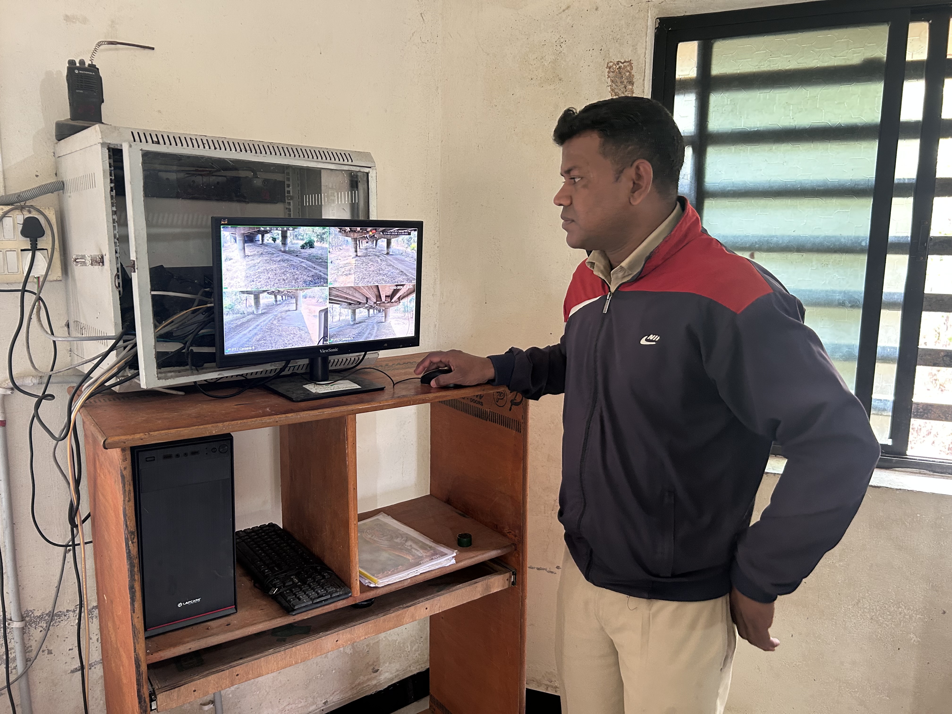
Umesh Sudhakar Bavle, a forest guard in the Pavani range of Pench Tiger Reserve, Maharashtra, checks CCTV footage in the monitoring room for underpass number eight. Photo: Yash Sadhak Shrivastava
Wildlife Underpass Usage
The Wildlife Institute of India (WII), which has designed and has been monitoring the Maharashtra underpasses using camera traps, has recorded at least 21 wild animal species, and 31 tigers from Pench and adjoining forests using the crossing structures, between 2019 and 2024. The structures are also used by leopards, wild dogs, sloth bears, Indian wolves and jackals, as well as ungulates including chital, sambar, gaur, wild pigs, barking deer, nilgai and four-horned antelope, and small mammals including jungle cats, Indian hare, rusty spotted cats, small Indian and common palm civets, Indian crested porcupines, Indian pangolins and grey mongoose. These findings, according to the report, indicate that these crossing structures are accepted by a wide variety of mammals in the landscape.
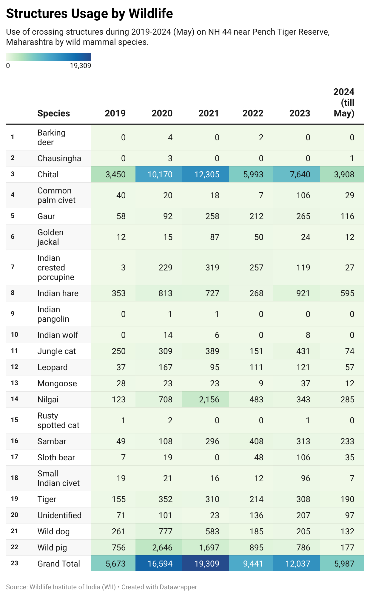
Source: Monitoring of Wildlife Underpasses on National Highway 44 passing through the Pench Tiger Reserve, Maharashtra 2019-2024, by the Wildlife Institute of India (WII) and the Maharashtra Forest Department.
_1774972531.jpg)
Researchers also observed an increase in the use of these structures by species that are typically averse to traffic disturbance, such as nilgai, gaur and female groups of sambar. Initially, mostly solitary males of these species were recorded using the structures, but over time, usage became more consistent across groups.
A steady and uniform pattern of use has been recorded for most species. Tigers, in particular, have been found to use all nine crossing structures to varying degrees, including breeding females moving with their cubs, according to the report.
The most frequently used structures are those located close to the boundary of the Pench Tiger Reserve. Larger structures, especially the one measuring around 750 m., recorded the highest number of unique tiger individuals, suggesting that wider crossings reduce the likelihood of roads creating artificial boundaries within animal home ranges.
CCTV systems are not used on the Madhya Pradesh side. Camera traps installed under the underpasses of NH 44 in MP have shown similar success, with repeated use by tigers, gaur, leopards, nilgai, and other animals. A Wildlife Conservation Trust study of the underpasses over 59 days in 2021 found that 23 wild species and five domestic species were using the structures, with the larger structures supporting multispecies use. The effort generated 16,708 images, which were filtered into 8,502 independent detection events.
In Madhya Pradesh, the 23 structures monitored include 14 animal underpasses, and nine structures, which were either built over streams or to allow drainage of rainwater.
The nine structures on the Maharashtra side and the seven in Madhya Pradesh on NH44 are an emblem of the slowly changing approach to wildlife conservation in India. Together, they play a crucial role in data collection and in monitoring potential poaching activity. They are an attempt to maintain the continuity of a much larger landscape that the highway slices through.
Landscape Conservation
The Pench Tiger Reserve is in the Central Indian and the Eastern Ghats tiger landscape. In the not-so-distant past, it would have been a contiguous landscape, with animals sharing a common gene pool. It is one of the largest tiger landscapes in India with about 31 per cent of the country’s tiger population. The tiger populations in the Protected Areas (PAs) here can only survive if they remain connected with each other through habitat connectivity, which would also protect other biodiversity and safeguard ecosystem functions. These animal thoroughfares have been protected to a certain degree by the notification of several conservation reserves.
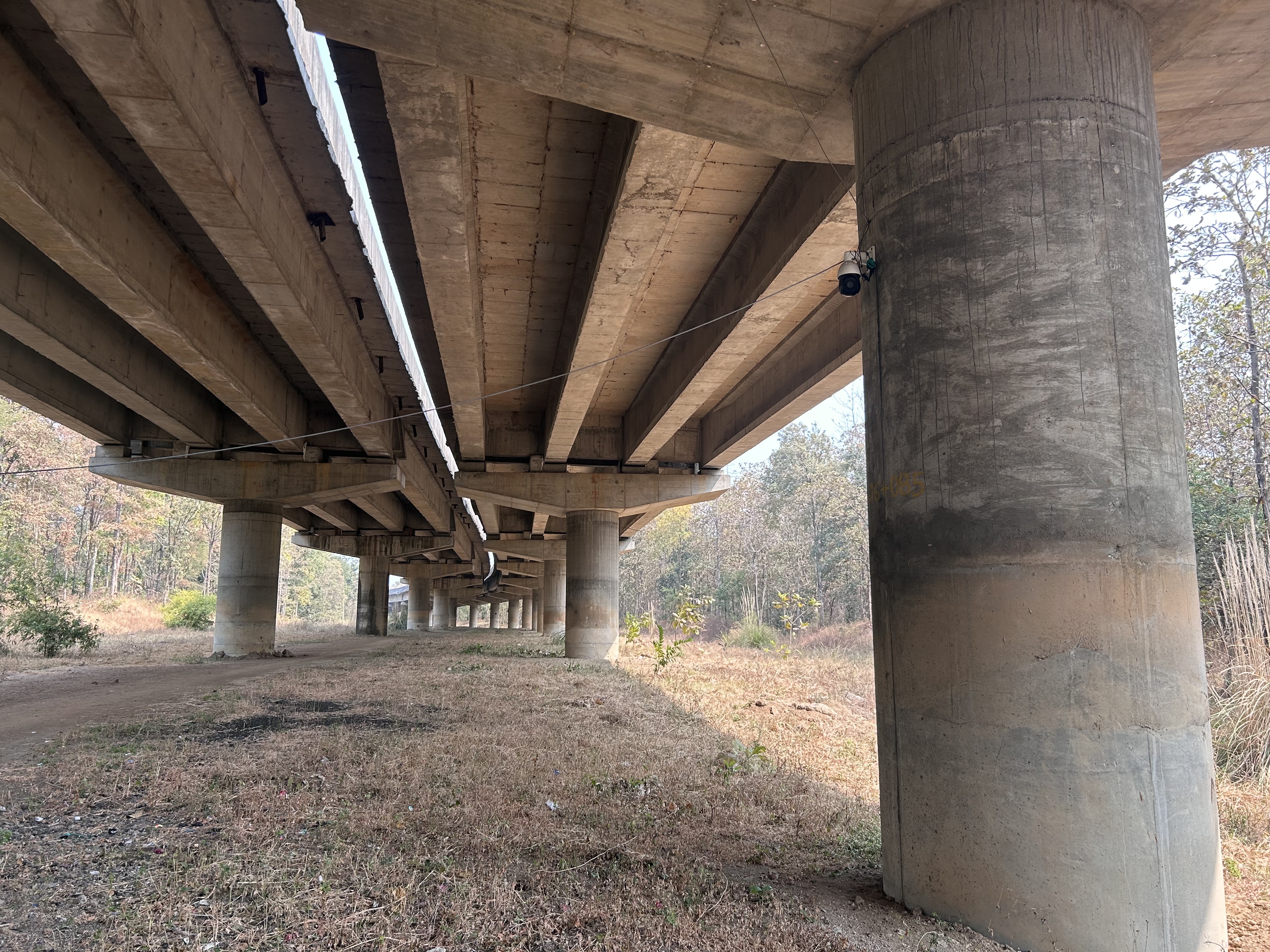
The 750-m. wildlife underpass on NH44 passing through the Pench Tiger Reserve in Maharashtra. Photo: Yash Sadhak Shrivastava
“Kanha-Pench and Pench-Navegaon Nagzira are crucial corridors, and the population of tigers has been continuously increasing. Tigers are now dispersing out, so if mitigation structures were not there, dispersion would not have been possible, which might have increased the risk of conflicts. Recently, a tiger killed a human in the Pench, Maharashtra area, and there have been confirmed cases of domestic cattle being killed. If the mitigation structures were not there, the number of casualties would have been much higher,” said Mandar Pingle, Deputy Director of Satpuda Foundation.
The 1,400-m. wildlife underpass on NH44 through the Pench Tiger Reserve in Madhya Pradesh is one of the longest such structures in India. Photo: Yash Sadhak Shrivastava
“The tragedy is that there has been no systematic effort to map wildlife corridors,” says Pariwakam, who is a member of the IUCN WCPA Connectivity Conservation Specialist Group. Pariwakam and Kolhe have found 192 corridors in the Central Indian and Eastern Ghats landscape, primarily from the perspective of tiger conservation and connectivity.
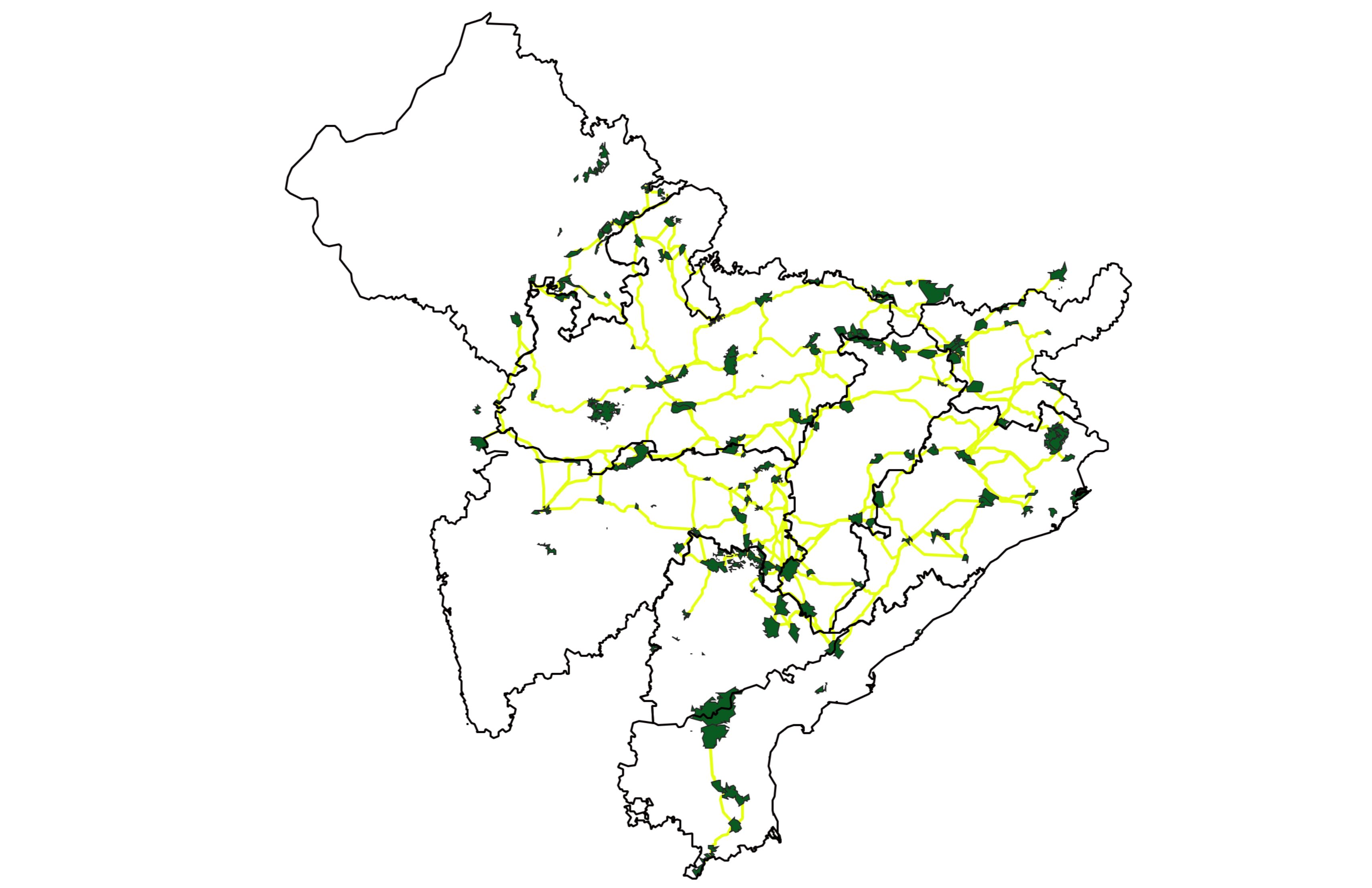
Milind Pariwakam and Sheetal Kolhe have identified 192 corridors in the Central India and Eastern Ghats landscape. The green areas are the Protected Areas and the yellow lines are the corridors. Source: https://landscapes.org.in/missingcorridors
However, the situation is represented differently in official documents. The National Tiger Conservation Authority (NTCA) has a ‘Decision Support System’ (DSS), which is used to evaluate developmental projects with respect to the location of tiger reserves and corridors. It shows fewer corridors than identified by Pariwakam and Kolhe, and it also comes with a disclaimer about the accuracy and suitability of this data. The NTCA and the WII write that there are 32 major tiger corridors in the country.
The number of demarcated corridors is not the only problem. “Many corridors are much wider than what official maps show,” said Joshi. “In several projects, only very small sections are mitigated because they are officially designated as corridors, even though animals use a much larger landscape.”
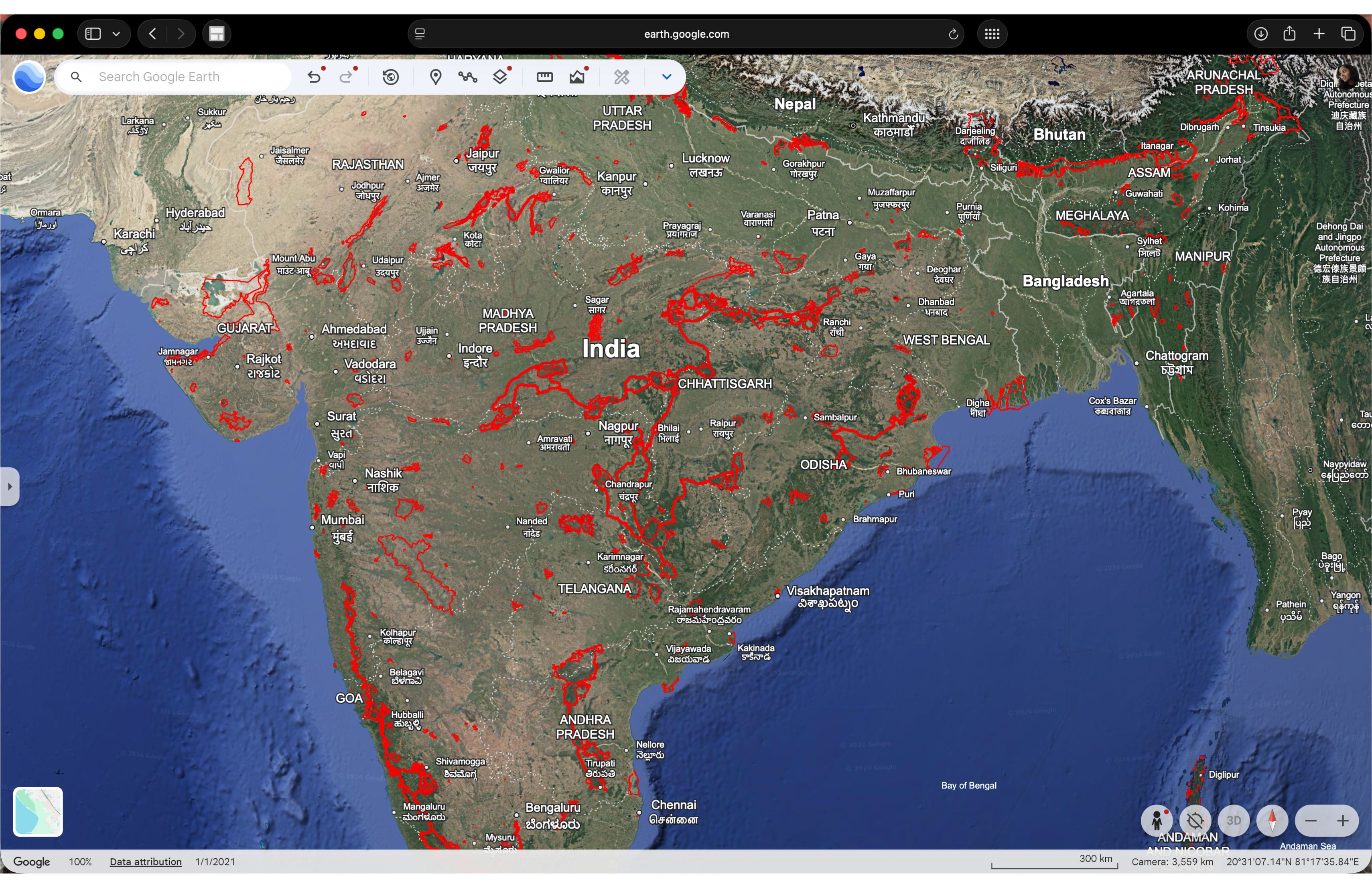
NTCA’s data showing Protected Areas and corridors. Source: NTCA’s Decision Support System.
Corridor protection has been identified as a strategy to ensure landscape connectivity and extend wildlife protection beyond Protected Areas since India’s second National Wildlife Action Plan (2002 to 2016). This NWAP stressed the need to identify corridors to prevent further isolation of biodiversity. It explicitly stated: “Ministry of Surface Transport ... to plan roads, highways, expressways in such a manner that all national parks and sanctuaries are bypassed and the integrity of the PA is maintained. Wildlife corridors also need to be avoided, or mitigative measures (such as restricting night traffic) need to be employed.”
Congruent to this, a 2013 Sub-Committee on Guidelines for Roads in Protected Areas under the National Board of Wildlife recommended fundamental principles that must be followed in order of priority: 1. Avoidance: The foremost option would be to altogether avoid areas that are within or in the vicinity of any Protected Area; 2. Principle of Realignment: Road projects must investigate and demonstrate that they have considered other alternative routes that avoid natural areas of high ecological value. 3. Principle of Restoration: In natural areas, existing roads that are in disuse (e.g., old logging roads), or evaluated to be inefficient or detrimental to their objects, shall be targeted for decommissioning and subsequent ecological restoration, as the process of assisting the recovery of an ecosystem that has been degraded, damaged, or destroyed.
This vision has taken a while to develop; the first NWAP (1983 to 2002) did not have such an approach, since the concept of landscape connectivity gained popularity only in the early 1990s, notes the Coalition for Wildlife Corridors. The third NWAP (2017 to 2031) also takes a landscape-level conservation approach: “Landscape-level conservation of species must be seen as maintaining or enhancing genetic exchanges between metapopulations and significantly improving the prospects of their long-term persistence. Therefore, the plans must address species loss in the short-term and the reasons for such depletions in the long run.” This includes securing corridors for large mammals such as tigers and elephants. Importantly, the third NWAP says: “Put in place institutional systems for objective assessment and consultation at the project formulation stage for ensuring that development projects as well as land-use practices in key wildlife habitats, do not turn out to be drivers of conflict.”
Goyal echoed these principles. “Ideally, mitigation measures should be incorporated at the project formulation stage itself,” he said. “During the preparation of the detailed project report, the ecological sensitivity of the area should be assessed and structures such as underpasses or overpasses planned accordingly. The best mitigation is avoidance, but where avoidance is not possible, mitigation must be built into the design from the beginning so that projects are not delayed later.”
The WCT report ‘A Policy Framework for Connectivity Conservation and Smart Green Linear Infrastructure Development in the Central Indian and Eastern Ghats Tiger Landscape’ identifies that most often, the user agency/project proponent is unaware about the ecological value of a particular forest patch where it is seeking forest land diversion. “The user agency prepares a Detailed Project Report (DPR) and budget without incorporating mitigation measures and submits the same for forest clearance. Most corridors either remain unidentified or are shrouded by a lack of awareness regarding them,” it states.
The Need for Mitigation Measures
As of 2013, at least 26 tiger reserves were impinged upon by roads from national highways to state highways and Public Works Department ones. Roads further break up fragmented natural habitats. They disturb migratory paths, split canopy cover, and also cause soil erosion and landslides. Roads are also the first step to increased anthropogenic footprints, which lead to disturbances such as garbage and pollution, and can even be conduits for poaching and illegal extraction of forest resources such as timber. Isolated wildlife populations are susceptible to inbreeding and have to depend on burdened ecosystems for survival. Highways also have a barrier effect – animals avoid crossing the road entirely. A study of tiger, leopard, gaur and chital on National Highway 44 showed that these species avoided the road more when the highway was upgraded from two-lane to four-lane.
The expansion of linear infrastructures, such as roads – integral to human society – poses a serious threat to wildlife, leading to road accidents, which have become major causes of terrestrial and avian wildlife mortality worldwide. A study conducted from June 2023 to May 2024 in the Nelliyampathy Hills, Western Ghats, Kerala, India, aimed to assess terrestrial and avian vertebrate roadkill, and the environmental parameters influencing it. In 22 roadkill surveys, 330 roadkills were recorded, representing 72 species, that included 228 individuals of reptiles (43 species) (66.09 per cent), 70 amphibian individuals (11 species) (20.29 per cent), 23 mammal individuals (10 species) (9.57 per cent), and nine bird individuals (8 species) (4.06 per cent). The annual roadkill estimate was 5,490 along a 50 km. transect, with an overall roadkill rate of 0.3 roadkills/km/year.
While the knowledge that roads disturb wildlife in and around Protected Areas and connecting routes is well established, the need and use of roads is only accelerating. A shorter time and the availability of end-to-end services for freight and people transport make roads a more attractive option. The share of railways in goods transportation has declined from 85 per cent in 1950-51 to 27 per cent, and roads dominate the transport share at 64 per cent (NITI Aayog 2024). In its Year-End Review 2025, the Ministry of Road Transport and Highways reported a growth of about 61 per cent of the National Highway network since 2014. As of 2025, the highway construction pace has risen to 34 km/day from 11.6 km/day in 2014, and there has been a 570 per cent increase in the road transport and highway budget from 2014 to 2023-24.
The need for measures to protect wildlife and its habitat is more urgent than ever.
Guidelines for Underpasses
In a bid to mainstream biodiversity conservation in linear developments, the NTCA along with the WII has published guidelines for linear infrastructure in 2016. ‘Eco-Friendly Measures to Mitigate Impacts of Linear Infrastructure on Wildlife’ aims to reduce mortality and make linear structures conducive to safe movement of animals across the landscape, as mandated under Section 38 O (1) (g) of the Wildlife (Protection) Act, 1972 – “ensure that the tiger reserves and areas linking one Protected Area or tiger reserve with another Protected Area or tiger reserve are not diverted for ecologically unsustainable uses, except in public interest and with the approval of the National Board for Wild Life and on the advice of the Tiger Conservation Authority”. The 150-page document carries forward the same principles of linear infrastructure planning as identified by the 2013 committee – avoidance, minimising impacts, restoring damaged areas, and compensation. It also urges planning mitigation measures early in the project planning cycle.
The guidelines include structural and non-structural options to address habitat fragmentation and maintain connectivity and animal movement, rather than focusing on reducing animal mortality. The structural options include land bridges and canopy bridges, which extend above roads and railways; glider poles, which are placed on the median to provide landing spots for gliding species; underpasses; and fences.
While these measures have been around for a decade, when a South African cheetah cub died in an accident on the Agra-Mumbai Highway near Gwalior, the MP Forest Department made red table-top markings on a two-kilometre ghat section of an 11.96 km highway project passing through the Veerangana Durgavati Tiger Reserve (erstwhile Nauradehi Sanctuary), as a mitigation measure to slow down vehicles in wildlife-sensitive areas. Experts and even forest officials have been unsure of the effectiveness of these markings.
“The idea of mitigation measures has been widely used in the West, where animals cross either above the road through overpasses or below through underpasses,” said Joshi. “However, in India’s forests, where multiple large species such as tigers, gaur and elephants share landscapes, underpasses have emerged as the most practical solution because they allow movement of animals of different sizes across long stretches of highways.”
Consequently, there are many options for underpasses in the guidelines. Bridges or viaducts elevate the grade of the road or railway, so that fauna can pass below. Box culverts are built under linear infrastructure for fauna, including aquatic species; pipe culverts are used by small mammals, reptiles and amphibians; and bridges across waterways maintain fish movement. The siting and design of underpasses is an exact science based on the behaviour and requirements of the species.
“Roads passing through forests are not only in corridors but often habitats where resident populations of tigers, leopards and wild dogs live on both sides of the road,” Joshi said. “Underpasses allow these animals to continue using their home ranges without risking crossing traffic. Even cubs and smaller species such as pangolins have been recorded using these structures.”
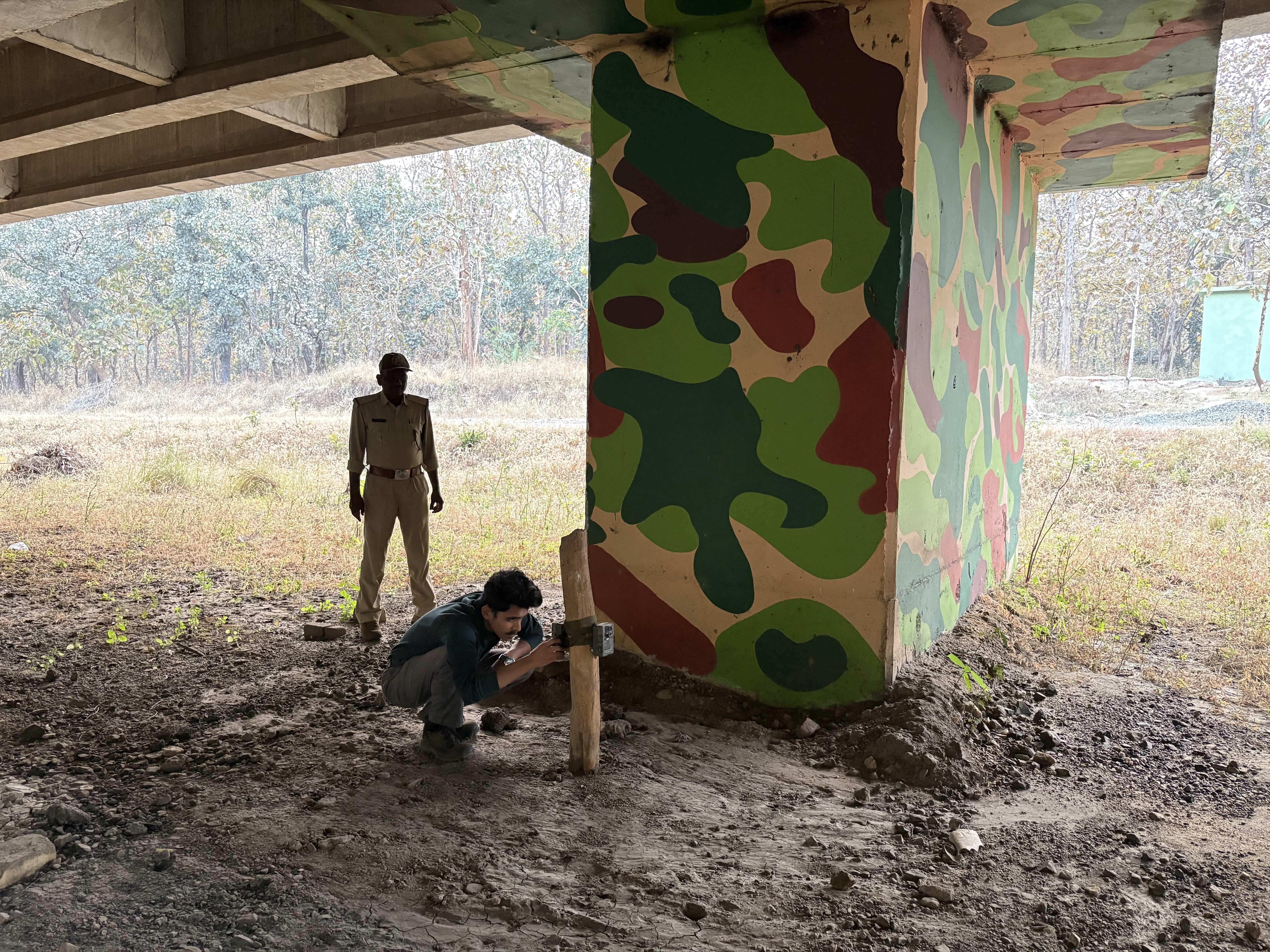
Camera trap installed at the 1,400-m. underpass on NH44 in the Pench Tiger Reserve, Madhya Pradesh. Photo: Shatakshi Gawade
Hiccups on the Ground
The restrictive interpretation of corridors, Joshi observed, is fundamentally dictating the manner in which wildlife mitigation measures are implemented. “If you look at all highway upgradation plans that are currently being implemented, where civil societies have not gone to the court asking for mitigation measures, they are just building on only those one-kilometre stretches. The rest is a corridor: forested and animals are using it. But they say it's not a corridor, so we don't have to build any mitigation measures,” shares Joshi.
Financial concerns are not far behind. In 2019, Minister of Road Transport and Highways Nitin Gadkari had said in Parliament how difficult it would be for a poor country like India to spend so much of resources on structures for wildlife. Mitigation structures are often avoided on the pretext that they greatly increase the required funds. “Each parcel of road upgradation is divided into units of around 50 km. to avoid environment clearances. The project proponents then say that for just 50 km, if a mitigation structure is 10 km, then the cost goes up. But the road project is not for 50 km. only. For instance, the NH44 upgradation project was from Delhi to Kanyakumari. The budget for wildlife mitigation structures is a small proportion then,” Pariwakam said. WCT also notes: Most often, the development agencies apply for project clearance on a piecemeal basis and develop the linear infrastructure outside the forest area. This presents a fait accompli situation to the regulatory authorities, who are forced to clear the project through forest land, quoting money already invested in a particular project. Despite multiple attempts, the office of Nitin Gadkari did not respond to the calls and emails.
Conservationists caution that the animal underpasses need careful management. “Growing human activity near wildlife corridors, including roadside dhabas and small establishments, may discourage animals from using these structures,” said Pingle. “In the Maharashtra stretch, the absence of light and noise barriers has also led to garbage dumping and disturbance near crossing points.” He added that trucks transporting chicken or goats sometimes dump carcasses near underpasses, which can attract wildlife towards the highway instead of the safe crossing structures. Forest guard Bavle of the Pavani range concurs, “We have to conduct weekly garbage cleaning drives, as people passing by refuse to listen.”
There are also some technical and logistical difficulties. Cameras often become defunct and monitoring becomes difficult owing to moisture during the monsoon, shared Bavle. Meanwhile, the WII report notes that camera traps are stolen frequently. Local villagers and highway users have been observed using the underpass frequently. WII also notes that rainwater remains under the underpass up to December, and that vehicular traffic can be heard loudly under the structure.
Frontline forest staff have observed that despite the presence of animal underpasses, some herds of chital and sambar still occasionally try to cross the highway. This is when Mukesh Sontakke, a forest guard in the Pavani buffer of the Pench Tiger Reserve, and his colleagues swing into action: they create enough noise to deter the animals, encouraging them to return to the forest. Langurs too end up crossing the highway, and sometimes don’t make it across.
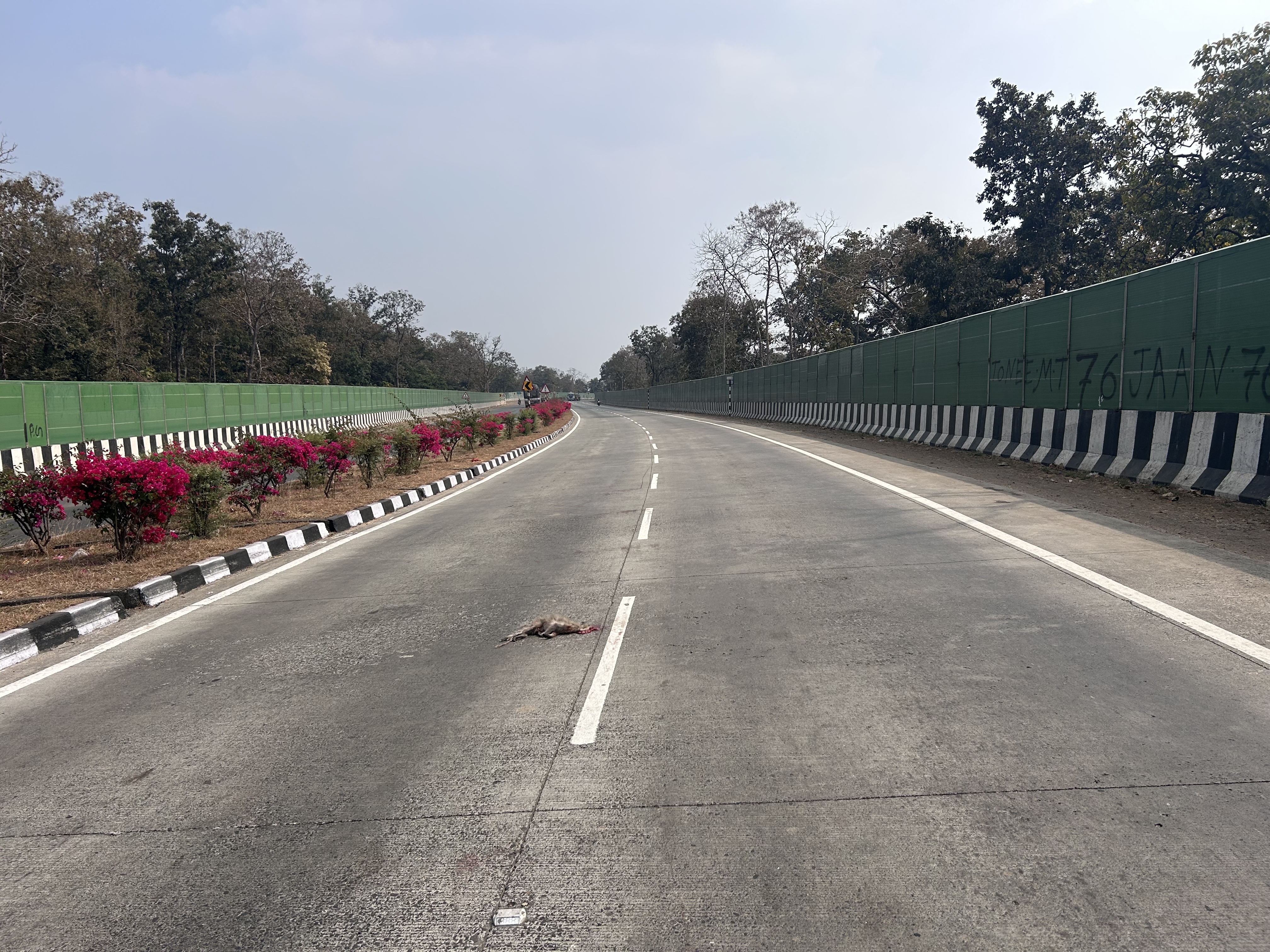
A langur killed in a road accident on an NH44 stretch in Madhya Pradesh, where noise and light barriers have been installed. Photo: Yash Sadhak Shrivastava
Measures for the Future
More mitigation structures are actually needed on NH 44. In their study ‘Recommendations for adding corridors to TCPs of 30 Tiger Reserves in the CI&EG Landscape’, Pariwakam and Kolhe have identified that NH 44 intersects 13 wildlife corridors, but mitigation measures have been implemented in only two of them.
The WCT report ‘A Policy Framework for Connectivity Conservation and Smart Green Linear Infrastructure Development in the Central Indian and Eastern Ghats Tiger Landscape’ also notes that the section from Seoni northwards towards Jabalpur (Madhya Pradesh) is without any mitigation measures, and the road cuts through the Kanha-Satpura corridor (in 2015). Mitigation measures are also required in Telangana, where NH 44 cuts through the corridors connecting the Kawal Tiger Reserve.
In fact, since the Central Indian landscape is in the middle of the country, several roads and railway lines cut through it. WCT suggests that a Cumulative Impact Assessment (CIA) or a Strategic Environmental Assessment (SEA) must be conducted to assess the overall impact on connectivity. It also recommends that solutions need to be project-specific, site specific, and science-based, and identifies that they are the mandate of the statutory agencies.
The need for animal underpasses goes well beyond NH44 and points to deeper structural issues. The first step is the scientific identification of wildlife corridors and their legal demarcation. Only then can appropriate mitigation measures be designed based on the species that inhabit a given landscape. There is already sufficient research showing that wildlife uses land far beyond designated Protected Areas. The underpasses on NH44 have demonstrated what is possible.
As climate change and poorly planned development continue to strain India’s biodiversity, it is time to let ecology and empathy guide decision-making. The construction of the NH44 underpasses is, in many ways, a story of struggle and hard-won success. Conservationists fought for nearly a decade, often at great personal cost, to secure these measures. There was hope that this victory would pave the way for systemic policy change, ensuring that future mitigation efforts would not require such prolonged battles. Yet, nearly five years after construction was completed, that hope appears only partially realised.
The absence of adequate mitigation structures elsewhere has led to increased human-wildlife conflict, often breeding resentment among communities living close to wildlife habitats. For generations, many of these communities coexisted with wildlife, but rising conflict, driven not by animals but by unplanned development, has strained that relationship. Responsibility for addressing this cannot rest solely on conservationists. It must also be shared by authorities and, importantly, by citizens at large.
This story is part of the Climate Narrative Hub’s work, developed in collaboration with The Migration Story.
Shatakshi Gawade is a Senior Editor at Sanctuary Asia, where she reports, edits and commissions stories at the intersection of biodiversity, climate change and economics. She has worked at The Asian Age, as an independent journalist, and as a communications consultant and campaigner with civil society organisations. You can find her on Instagram, LinkedIn, and Facebook.
Yash Sadhak Shrivastava is an environmental and business journalist. His work has appeared in respected outlets including Context News, Moneycontrol, The Indian Express Group, Down To Earth, and others. He has received multiple fellowships from the Earth Journalism Network and the Thomson Reuters Foundation. You can find him on Instagram, LinkedIn, and Facebook.